Apple recently acquired HopStop, the public transit app for iOS and Android that gives transport data to users in over 300 cities worldwide with transit maps, journey planners, and multiple options to reach a destination. The app isn’t without flaws, but what makes HopStop (on iOS and Android) one of the most popular public transit apps on the market is the integration of a ton of data.
There are plenty of public transit apps out there that incorporate data collected by public transport authorities from all over the world, data which is usually free and available for developers to play with. This data, along with some other essentials, has the potential to create an app that makes any trip outside your front door as smooth as possible. Below, we outline some of the most essential considerations needed to create the mother of all transit apps!

The Necessities
Good maps
This is a no-brainer. Apple purchased HopStop in part because of its need to improve its much-criticized maps application, and the uproar created when Google maps briefly disappeared from the iPhone is testament to just how important a good map application is. First and foremost, a public transport app that is meant to get you around should show you how it intends to do that.
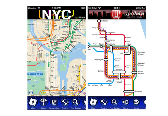
Of course, it should also include public transit maps. MXData, for example, produces simple but really great subway maps for cities all over the world, letting you search stations and plan the quickest route from one stop to another.

Options
If you’re accustomed to taking the subway everywhere, you tend to think in subway stops as opposed to the actual distance between them, and you might forget just how easy it is to get from point A to point B without having to transfer to 3 different subway lines. Taking the bus, cycling, or walking might be the easiest, quickest, or even cheapest mode of transportation. Apps that compare the time it takes you to get somewhere using different modes of transportation, or that let you filter by which type of transportation you want to take, can really save time.
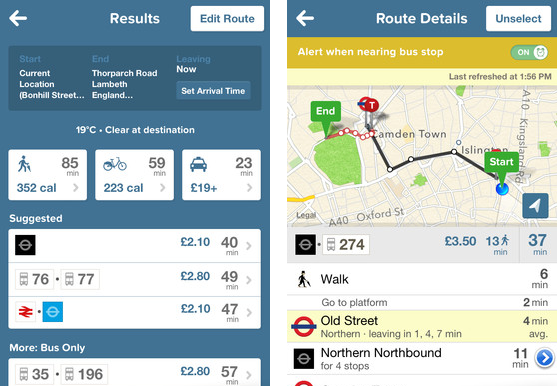
CityMapper for iOS and Android is probably one of the best apps on the market for this. It not only compares the time it takes to get somewhere by subway, by bus, by bike, by foot and by taxi, it also tell you how much each mode of transportation will cost and how many calories you’ll burn by walking or cycling. CityMapper has a really well-implemented comparison tool but unfortunately, the app is only currently available for the city of London.

Real-time schedules and updates
In a perfect world, the quickest way to get somewhere would always be the same. Alas, we don’t live in a perfect world, and things like traffic, disruptions and delays can make our lives a lot harder when we’re trying to get somewhere quickly and conveniently. Incorporating live travel updates, subway and train line closures, delays, construction, and traffic reports into an app is a really good way to help us make the right decision before we step out the door.
This is where data collected by public transit authorities can really come in handy. A lot of big cities already collect this data (like when you’re waiting for the subway and can see how long it will take for the next train to arrive, for example) and make it available to developers for free: it’s just a matter of being able to use it effectively.
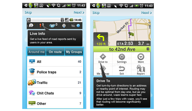
Another recent trend is using crowd-sourced data to get live traffic reports from other users, a sure way to get spot-on traffic info. A crowd-sourcing app like Waze for iOS and Android is a great way to get accurate and timely traffic data in real time, but this app is only as useful as the number of people using it in your specific area. HopStop has recently added something similar for their iPhone app with live travel updates from users.

Similarly, with lots of cities now offering bike sharing programs, there’s even room to incorporate data about bike availability at docking stations into an app.
Wish List
There are other additions that, although not essential, can help make travel apps even more useful.
Weather reports
Walking might be quickest, but not ideal if its going to rain. Incorporating weather reports would be a simple but handy addition to the ultimate transport app.
Saved locations
Being able to save locations and most-frequented routes is also key. People generally travel the same routes on a daily basis, and having those locations on hand can save a lot of time and trouble. Again, CityMapper and its ‘Get Me Home‘ function is a great example in this instance. It saves your home location and gives you immediate directions to get you home from anywhere, at anytime, in the city. Useful among Saturday night revelers, I’m sure.
Ticketing
Every city has different ticketing systems so it could be hard to integrate them all into one app, but for things like rail service, adding the option to purchase tickets within the app could save a lot of time. Similar is the option to order and pay for a taxi, much like super app Hailo, which gives you detailed info on how many taxis are in your vicinity, letting you order and pay for your journey without having to say more than two words to the taxi driver.
At the end of the day, all of these functions ARE available, but separately. Some apps have begun to integrate more and more public transport info into one with various levels of success. For now, CityMapper proves to have one of the best formulas, with comparative routes, maps, weather, live bus and tube departure times, and even integrates London’s public bike share program into the app.
Given that London has one of the most complex public transport systems to navigate, there is hope that this template can be recreated in a way that services more cities!

